
The JMT provides beautiful views at almost every step, so it’s ridiculously easy to find a breathtaking place to eat lunch or make camp. Malcolm was the lead “site finder,” having the energy and patience to spend 15-30 minutes searching for a good flat site that was near (but not too near) water and possessed wind potential (for blowing away mosquitoes). During this time I usually played the ever-important role of “pack protector”, defending our belongings from potential marmots and other intruders. Below are a few of some our favorite places we spent the night and/or saw along the way.
Devils Postpile:
We took a short side hike to visit Devils Postpile National Monument, which had been recommended by Malcolm’s dad. The postpiles are basalt columns that formed 100,000 years ago when lava flowed down the valley and was dammed at this particular spot. As the lava cooled, it formed long vertical columns that are almost perfectly hexagonal when looked at from the top. You can look at the side view, and then hike to the top to see the hexagonal shapes from the top. It was worth the extra mile, plus we felt bad-ass since everyone else was just walking in from their cars and we had giant packs (and were very dirty in comparison).

Virginia Lake:

We had one of the best sunsets while camping above Virginia Lake. Earlier in the afternoon we had narrowly missed a few thunderstorms, and the lingering thunderclouds plus the rising full moon made for a phenomenal light show. We paid for the view in mosquito bites.


Florence Lake/Muir Trail Ranch:

We camped above Florence Lake the night before our resupply. The sun sunk as we made dinner, turning the sky and water shades of pink and purple. In the morning we were visited by a few “free-range” mules that wandered into camp and were very happy to have their ears scratched. We hiked 5 miles to Muir Trail Ranch, where our two 5-gallon buckets of food awaited us!

The MTR is only a mile off the JMT, which while convenient for hikers makes it very hard to access. It’s so remotely located that the hiker food and other supplies are brought in either by mule trains or giant Mercedes hummer-like vehicles. There was a cute old woman who ran the hiker-resupply. The buckets of food she was carrying around probably equaled her body weight, and she was so short that I worried she might pinch a nerve trying to look up at Malcolm while they talked!

We were very excited to find we had mail waiting for us at the ranch; a box of delicious fruit leather and Bear Naked granola mixes from Chris and Jen!
Ansel Adams Pond:

The rangers recommended we check out this spot, which was unmarked on our map. One of AA’s famous photographs was taken at this tiny lake, and we spent a beautiful evening there enjoying the sunlight on the mountains all around. I broke out the black and white feature on the camera in honor of Mr. Adams.

The pond was filled with tiny fish, shrimp and the elusive yellow-legged frogs, which we failed to see.


In the 2nd half of the trip the trail develops a steady pattern of 8-10 miles of climbing followed by 8-10 miles of descending. We would conquer a pass at least every other day and would usually enjoy the view while taking a break or eating lunch.
San Joaquin River/Evolution Lake/Muir Pass:
Oh man, this was a beautiful park of the trail. We walked right along the river valley for a few miles, twenty feet above the water with views of the canyon in both directions. At one point the trail climbed up and around a giant rock formation called John Muir Rock, with a sheer 50-foot drop to the river on the right and amazing views. We passed through fields of quivering Aspens and camped on the river bank that night (well, 40 yards from the river bank, of course).

The following day the trail climbed several thousand feet and passed through beautiful meadows filled with wildflowers. We stopped while we had a view of the San Joaquin River Valley to take some pictures plugging Bear Naked Granola, our non-official sponsor. By the end of the day we had climbed above 10,000 feet and camped at Evolution Lake with an unbelievable view of the river valley we’d be hiking along all day.


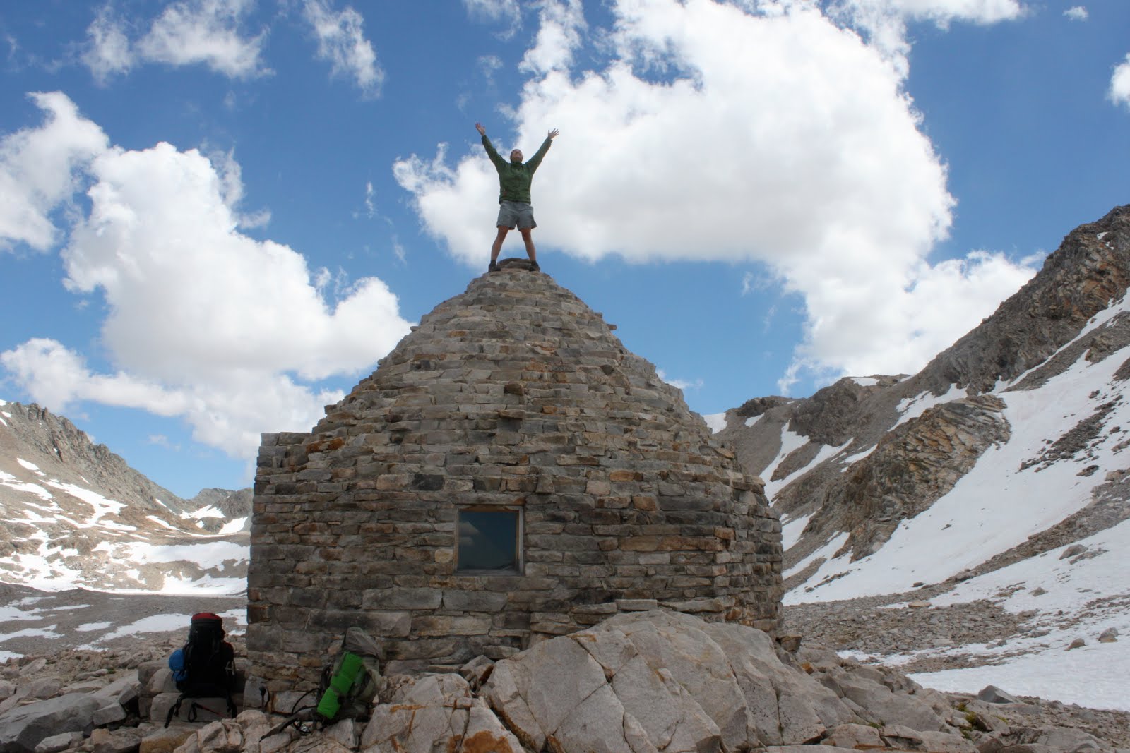
The following morning we hiked past some of the most beautiful lakes of the entire trip. Clear, bright blue and green water revealed the presence of giant boulders lying on the bottom. Muir pass was the only pass with a shelter on top, designated for emergencies only (we’re not on the East coast anymore, ToTo.) I couldn’t help but notice the roof of the shelter was begging to be climbed, so we each took a turn on top!

Rae Lakes/Glen Pass:

This beautiful series of high mountain lakes is just a few miles below Glen pass, with mountains all around reflecting in the water. We took a much-needed swim and camped by Lower Rae Lake. These lakes are a little more accessible than some other parts of the trail and are often crowded, but we lucked out and had the lake to ourselves.


Forester Pass was the last pass before Mt Whitney, and the highest one of the trail so far (13,100). We tackled it first thing in the morning, leaving from a beautiful campsite with 360 degree views of sheer mountainsides and waterfalls.

The descending trail demonstrated some amazing trail building, with steep switchbacks cut into the side of the mountain. Looking back up it seemed a little unbelievable that we had actually come down that face.

Loved your post and great pic of Malcolm and the "cute old woman". Patt is 82 years young and my mom. Would love to be able to copy the pic into my photo collection with your permission?
ReplyDeleteChristine
sanukgray@gmail.com