Monday, August 23, 2010

48 Hours in San Francisco


If I were judging cities based only on their dog population, San Francisco would be ranked number one. Mid-sized, mixed-breed dogs were spotted throughout the city parks and streets...my kinda town! Even without the dogs, I really enjoyed my time in San Francisco! Delicious food (more tacos of course), funky stores and great parks took up most of my time.

When I arrived on Sunday night we got right down to business and went to the Giradelli factory to sample their chocolate (it was a caramel free-sample day)! We went to a fantastic little Mexican restaurant for dinner where we ordered the largest bowl of guacamole I have ever seen!

Since Dan was working, I had two full days to explore on my own, connecting back up with Dan for dinner each night. American Idol was holding auditions in the city while I was there (information I learned from an AI hopeful on the bus/train ride from LA). I expected things to be a little crazy, since 20,000 to 30,000 people were expected to show up, but the city seemed to be big enough to hold us all.

Day one started with a great run along the panhandle and through golden gate park where I saw the following sign at the intersection of the park and the road:


Love it.

The rest of the day was spent walking around the Mission district, which was conveniently close to Dan’s place. I walked into a used bookstore on Market Street, emerging a quick 2 hours later with a handful of new additions to my library. Next I grabbed an ice cream cone from Bi Rite, salted caramel and coffee toffee, sooo delicious! I then stumbled into a combination children’s mentoring non-profit/pirate supply store, a pretty awesome combination! Next door was another creatively stocked business, selling various plants and gardening materials in the back and taxadermied animals and animal-inspired art in the front (think blown ostrich eggs, jewelry molded after animal bones and glass eyeballs)! After a few chapters of JD Salinger in Dolores Park, it was time to join Dan and our friend Ashley for dinner (fantastic seafood tacos) and a bottle of wine.


I borrowed Dan’s bike on day two and traveled downtown, thoroughly enjoying and appreciating the well marked bike lanes. I biked by the fisherman’s wharf and along the waterfront bike path to the golden gate bridge. The sidewalk was crowded but the skies were clear and it was a beautiful day to ride across the bridge and back. After backtracking through downtown I rode through Haight and Ashbury before joining Dan for dinner and hopping on my flight to Seattle!

Sunday, August 22, 2010

The Promised Land


Since Los Angeles was our first real stop after leaving life on the trail, it had the chance to live up to the nickname “the promised land.” Ahh the luxuries that awaited us; running water, hot food of all kinds, soft beds with sheets and most importantly, Chris, Jack, Kim and Erin! How lucky am I that I can visit so many best friends in one city?! Malcolm navigated us with expertise through the 7-lane traffic of The 5 (a little different than the sparsely populated two lanes of I-89 in VT) and we arrived at our LA haven, Jack and Kim’s house in Echo Park.


The McLoughlin-Strobel family of four (including new kitten addition Abe the Babe) welcomed us back to society in style. We were eating things like fresh fruits, vegetables and non-freeze dried entrees, soaking up the sun on the beach and enjoying delicious margaritas- this city is amazing. Evening walks around Echo Park revealed funky architecture and amazing gardens (the things you can do when your garden survives 12 months of the year!)

Kim and Stella led me on a sunny hike of Mt Hollywood, and I gained a few pounds back by spending lunchtime at Local, Jack’s restaurant. A portabella and goat cheese burger accompanied by crispy spicy fries, curried chicken salad on a bed of fresh kale…perfection!

We celebrated Jack’s birthday with a backyard BBQ, complete with a piƱata and ice-cold forties-an appropriate welcoming of year 27.


Erin showed me the lay of the land in Santa Monica, including a stroll down the 3rd Street Promenade and delicious tacos. I’ve come to the conclusion that I could happily eat every meal out of a flour tortilla or taco shell for the rest of my life!

Chris took a turn at hosting and we spent a little time in downtown LA where I checked off the “dancing to late 90’s music” and “drinking tall boys of PBR” items on my to-do list.

Of all the modern joys that Los Angeles offered, quality catch-up time with good friends tops the list.
(Though those margaritas WERE good…)

Thursday, August 19, 2010

Trail Homes


Guest-blogger Malcolm has put together a blog about our campsites along the trail:


Our JMT campsites starting 7/19/2010 at Toulomne Meadows and ending 8/6/2010 at Whitney Portal:

7/19: Lyell Canyon 5.5 miles south from Toulomne Meadows, right off trail by nice river spot
7/20: Just above Donahue pass to the right on the ridgeline
7/21: Left before the bridge at Garnet Lake behind the large smooth rock, sandy campsite
7/22: Left of trail at the Becks Lake trail junction,
7/23: Madera/Fresno County line, right of trail in the woods
7/24: High point between lake Virginia and Purple lake, right off trail and up ridgeline
7/25: Lake Edison trail 1 mile above ferry landing right of trail
7/26: Vermillion Valley resort
7/27: Bluffs above Florence lake 1 mile from ferry landing, right from trail
7/28: San Joaquin River Valley, right after second bridge in Kings Canyon NP, in the trees by river
7/29: North Evolution lake, across creek at the north end of lake on the ridgeline
7/30: Le Conte Canyon 3 miles below Muir Pass left across the creek
7/31: Woods left of trail about a half mile before the golden staircase begins
8/1: Upper Basin on the south side of Mather Pass, left of trail between the 4 lakes
8/2: Ansel Adams pond, left of trail on small bluff in trees
8/3: Lower Rae Lake, right of trail at first penninsula
8/4: 3 miles below Forester Pass at 90 degree turn in trail on right across Bubb's Creek
8/5: Bighorn Plateau, right of trail in dried river bed
8/6: 1 mile above Guitar lake right of trail

And now, the JMT campsite POWER RANKINGS:

All sites were rated out of 20 in the following 5 categories, scores are out of 100:

S= Scenery. How pretty was it?
C= Campsite. How nice were the tent site and cooking area?
W= Water. A combo of access to water for filtering and the quality of the water itself
M= Mosquitos. How bad were the bugs?
X= X factors. Anything else that contributed to the experience: wildlife, neighbors, weather, etc.

#18: Madera/Fresno County line: Easily our worst campsite. No view, very buggy, and I had to hike 10 minutes down to get water. Not a great night.

S=5, C=10, W=5, M=4 , X=2
Total = 26

#17: Becks Lake trail junction: Bugs were OK until dusk and a decent campsite with good water, but not much of a view.

S=6, C=15, W=10, M=7, X=7,
Total = 45

#16: Lake Edison Trail: We hiked all day and crashed right by the trail. Our only rainy night with a few thunderstorms.

S=8, C=8, W=16, M=8, X=8,
Total = 48


#15: Donahue Pass: Great view, but bad bugs and a good hike down to water.

S=18, C=10, W=4, M=6, X=14,
Total = 52


#14: Above Lake Virgina: Very beautiful...bugs so bad we ate dinner in the tent. Closest water down at Purple lake.

S=19, C=15, W=6, M=2 X=15,
Total = 57


#13: Base of the Golden Staircase: Nice site in woods by the creek, mosquitos controlled by campfire (below 10,000 feet!)

S=8, C=14, W=16, M=9, X=14
Total = 61

#12: Upper Basin below Mather Pass: Exceptional view and good water. Horrible mosquitos

S=18, C=18, W=15, M=3, X=12,
Total = 66


#11: Lyell Canyon: Mosquitos not bad and a lovely riverside spot.


S=14, C=12, W=17, M=12, X=12,
Total = 67


#10: San Joaquin River: Beautiful wooded spot on the rver, campfire helped with bugs


S=12, C=17, W=19, M=12, X=15,
Total = 75

#9: Bighorn Plateau: Majestic views with a nice breeze. Stagnant water and our coldest night...brrr

S=20, C=17, W=8, M=16, X=16,
Total = 77


#8: Garnet Lake: Awesome tentsite and rock for cooking. A little crowded but good water and bugs OK.

S=15, C=19, W=12, M=15, X=17,
Total = 78


#7: Florence Lake: Gorgeous and bug free. No water above the lake.

S=12, C=17, W=7, M=20, X=18,
Total = 79


#6: Le Conte Canyon: Excellent campsite above the creek. Great views, water, and not many bugs.

S=16, C=16, W=16, M=16, X=16,
Total = 80

#5: Ansel Adams Pond: Incredible views, 4-5 good tent sites above the pond on a ridge with a nice breeze to keep bugs away. We couldn't find the yellow legged frogs the ranger told us about...

S=19, C=19, W=8, M=16, X=19,
Total = 81


#4: Lower Rae Lake: Everyboby else camped at the upper lakes, we had this one to ourselves! Great swimming spot, not
many bugs, and excellent scenery. I wish I'd had a fishing pole for all the big trout we saw!

S=18, C=18, W=15, M=15 X=17,
Total = 83


#3: Above Guitar lake: Away from the crowds, and no bugs at 12,000 feet! We ate well and enjoyed a gorgeous sunset. Carried water up from the lake but crossed a few streams on the way. Tented on a sandy flat spot with a rock wall built around it.

S=20, C=18, W=7, M=20 X=19,
Total = 84


#2: North Evolution Lake: Good swimming and water, great view and tentsite, breezy to keep away bugs, and a killer sunset. I though it couldn't be beat, but...

S=19, C=18, W=18, M=17, X=18,
Total = 90


#1: Bubbs Creek: Stunning views, a fast flowing water source, and a tent site bunkered behind rocks with a little meadow in the backyard. Very few bugs and one of the best nights of the trip! Our neighbor gave us some teriyaki chicken, so that didn't hurt either.

S=18, C=20, W=20, M=18, X=17,
Total = 93


The Final Climb: Mt Whitney


"In every walk with nature, one receives far more than he seeks" -John Muir


The alarm went off at 2 am, and we sleepily made a quick breakfast and broke camp under the stars. Headlamps shining, we started our 4-mile ascent up Mt. Whitney around 3 am. Night hiking has the advantage of masking your progress, or lack-there-of. You really have no choice but to focus on the next step and nothing more, which was a nice change of pace. We would take a break every twenty minutes or so and turn our headlights off to enjoy the stars. The night was so clear we could see the swirling pattern within the Milky Way, an unbelievable sight. We could also see a few fellow hikers climbing below us, represented by tiny lights barely moving in the distance. They resembled lightning bugs as their lights blinked on and off while they turned switchbacks.
Around 4:30 we arrived at Whitney Junction, where the JMT merges with the Whitney Portal Trail and both trails climb a final two miles to the summit. We stashed most of our belongings to lighten the load for the last part of the climb and continued on our way. The trail hugged the north face of the mountain, winding through tall columns of rock, silhouetted by the rising crescent moon and the first inklings of dawn. The pitch was more moderate now, and a ridgeline path took the place of the previous switchbacks. Several times the trail passed over narrow ledges with steep drops to both sides. Through these brief openings in the mountain of rock to our right we could see the lights of Lone Pine below, as well as the colors forming on the horizon. At one point the trail made a sharp right turn revealing 3 jagged peaks, the Keeler Needle, the Day Needle and the Mt. Whitney summit.


Twenty minutes and a short serious of switchbacks later, we were standing on what felt like the top of the world. The sun rose over a thin line of clouds, turning the northern horizon orange and the southern horizon blue and purple. As we looked behind us, we saw a small, triangle shape on the clouds—Mt. Whitney’s shadow!


A tiny plane swooped towards us, buzzing the top of the mountain as we jumped and waved. The pilot took a wide turn and made a second, even closer pass. As we stood on the highest peak in the lower 48, the significance of the moment sunk in and I shed a few emotional tears. I couldn’t imagine a more perfect finale to the trail. We shared the summit with only one other hiker and we put him to good use taking our picture!


Mt. Whitney’s summit may be the terminus of the John Muir Trail, but there unfortunately is not a shuttle to the road to Lone Pine. Instead we had an 10-mile decent losing 6200 feet of elevation. So after about 45 minutes on the summit we began our final hike. Traveling back through the now sun-lit rock formations was like hiking down a new trail, and we passed several of our trail friends on their way to the top.


(view of the Needles from Mt. Whitney)

As we claimed our packs at Whitney Junction and began hiking down the southern face of the mountain we began passing dozens of people who were out for either the just day or the weekend. We had officially left the environmentally-conscious, quiet world of backcountry hikers and had entered what we deemed “struggle city.” My 3 favorite quotes from people we passed that day are as follows:

1-At the foot of approximately 100 steep switchbacks, a California bro with aviator sunglasses inquired: “Excuse me, but are these what they call ‘the switchbacks’?”
2- In response to my “enjoy your hike,” a slightly terrified man clinging to the side of the trail said “I DOUBT it!”
3-In response to my “well, it’s a beautiful day”, a woman with altitude sickness replied: “Yeah, it’s a beautiful day to throw up!”

A few hours later we stepped into the Whitney Portal parking lot, walked 50 feet to the right and consumed the best burger and fries I have ever eaten. By 6pm we were sitting in a BED drinking local California BEER and eating TACOS. A beautiful end to a beautiful trip!


(Stay tuned for a special guest-blogger!)

Tuesday, August 17, 2010

THINGS


I don’t have much to say about the wildflowers we saw, because I zoned out and forgot to buy a JMT trail guide before we left (though maybe it’s better given our pack weight!) It’s apparently ideal to time your hike just right so you catch the wildflowers still in full bloom but miss the worst of the mosquito season. Unfortunately the bloodsuckers were still in full force while we were on the trail, but the wildflowers did their best to make up for it, with breathtaking colorful shows. There were days where I fell far behind Malcolm on the trail because I couldn’t stop getting my camera out to document these beauties.


While we didn’t see any bears on our trip, we did see a fair share of deer, birds, chipmunks, lizards, frogs, tons of fish and of course marmots. The stellar jays, in particular are abundant on the trail, making their presence known with loud quick calls.


Malcolm had a potential pika spotting (a chinchilla-like animal in the rabbit family), but as Bruce and Heidi warned us, they’re very quick and the sighting remains unconfirmed…

Monday, August 16, 2010

PLACES


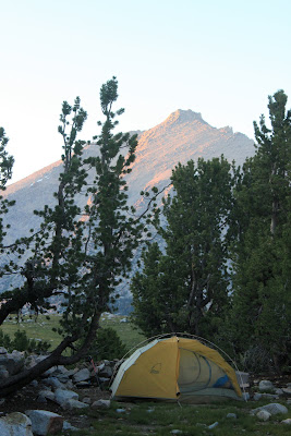
The JMT provides beautiful views at almost every step, so it’s ridiculously easy to find a breathtaking place to eat lunch or make camp. Malcolm was the lead “site finder,” having the energy and patience to spend 15-30 minutes searching for a good flat site that was near (but not too near) water and possessed wind potential (for blowing away mosquitoes). During this time I usually played the ever-important role of “pack protector”, defending our belongings from potential marmots and other intruders. Below are a few of some our favorite places we spent the night and/or saw along the way.

Devils Postpile:
We took a short side hike to visit Devils Postpile National Monument, which had been recommended by Malcolm’s dad. The postpiles are basalt columns that formed 100,000 years ago when lava flowed down the valley and was dammed at this particular spot. As the lava cooled, it formed long vertical columns that are almost perfectly hexagonal when looked at from the top. You can look at the side view, and then hike to the top to see the hexagonal shapes from the top. It was worth the extra mile, plus we felt bad-ass since everyone else was just walking in from their cars and we had giant packs (and were very dirty in comparison).


Virginia Lake:


We had one of the best sunsets while camping above Virginia Lake. Earlier in the afternoon we had narrowly missed a few thunderstorms, and the lingering thunderclouds plus the rising full moon made for a phenomenal light show. We paid for the view in mosquito bites.


Florence Lake/Muir Trail Ranch:


We camped above Florence Lake the night before our resupply. The sun sunk as we made dinner, turning the sky and water shades of pink and purple. In the morning we were visited by a few “free-range” mules that wandered into camp and were very happy to have their ears scratched. We hiked 5 miles to Muir Trail Ranch, where our two 5-gallon buckets of food awaited us!


The MTR is only a mile off the JMT, which while convenient for hikers makes it very hard to access. It’s so remotely located that the hiker food and other supplies are brought in either by mule trains or giant Mercedes hummer-like vehicles. There was a cute old woman who ran the hiker-resupply. The buckets of food she was carrying around probably equaled her body weight, and she was so short that I worried she might pinch a nerve trying to look up at Malcolm while they talked!


We were very excited to find we had mail waiting for us at the ranch; a box of delicious fruit leather and Bear Naked granola mixes from Chris and Jen!


Ansel Adams Pond:


The rangers recommended we check out this spot, which was unmarked on our map. One of AA’s famous photographs was taken at this tiny lake, and we spent a beautiful evening there enjoying the sunlight on the mountains all around. I broke out the black and white feature on the camera in honor of Mr. Adams.


The pond was filled with tiny fish, shrimp and the elusive yellow-legged frogs, which we failed to see.


In the 2nd half of the trip the trail develops a steady pattern of 8-10 miles of climbing followed by 8-10 miles of descending. We would conquer a pass at least every other day and would usually enjoy the view while taking a break or eating lunch.


San Joaquin River/Evolution Lake/Muir Pass:

Oh man, this was a beautiful park of the trail. We walked right along the river valley for a few miles, twenty feet above the water with views of the canyon in both directions. At one point the trail climbed up and around a giant rock formation called John Muir Rock, with a sheer 50-foot drop to the river on the right and amazing views. We passed through fields of quivering Aspens and camped on the river bank that night (well, 40 yards from the river bank, of course).


The following day the trail climbed several thousand feet and passed through beautiful meadows filled with wildflowers. We stopped while we had a view of the San Joaquin River Valley to take some pictures plugging Bear Naked Granola, our non-official sponsor. By the end of the day we had climbed above 10,000 feet and camped at Evolution Lake with an unbelievable view of the river valley we’d be hiking along all day.


The following morning we hiked past some of the most beautiful lakes of the entire trip. Clear, bright blue and green water revealed the presence of giant boulders lying on the bottom. Muir pass was the only pass with a shelter on top, designated for emergencies only (we’re not on the East coast anymore, ToTo.) I couldn’t help but notice the roof of the shelter was begging to be climbed, so we each took a turn on top!


Rae Lakes/Glen Pass:


This beautiful series of high mountain lakes is just a few miles below Glen pass, with mountains all around reflecting in the water. We took a much-needed swim and camped by Lower Rae Lake. These lakes are a little more accessible than some other parts of the trail and are often crowded, but we lucked out and had the lake to ourselves.


Forester Pass was the last pass before Mt Whitney, and the highest one of the trail so far (13,100). We tackled it first thing in the morning, leaving from a beautiful campsite with 360 degree views of sheer mountainsides and waterfalls.


The descending trail demonstrated some amazing trail building, with steep switchbacks cut into the side of the mountain. Looking back up it seemed a little unbelievable that we had actually come down that face.